
We often hear that the world is getting smaller, as people travel with greater speed and frequency. New data released this month confirms this trend within the UK, with the country feeling smaller as we travel further afield in commuting to work. As a result, the economic footprint of cities is larger – and 15 cities have effectively been wiped off of the map entirely.
The economic logic of cities argues that bringing people together in workplaces and business districts enhances productivity and drives growth. The promise of greater productivity (derived from such “agglomeration effects”) underpins the government’s commitment to giving city-regions like Greater Manchester more power to run their own affairs.
While ONS published Census-based commuting data a few years ago, they have only just finished crunching the numbers which allow them to redraw the map of travel-to-work areas (TTWAs). Here the UK is defined purely by commuter patterns; blissfully ignorant to administrative boundaries.
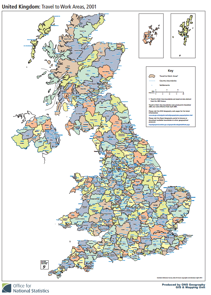
The 2001 TTWA map. You can see a larger version on the ONS website here.
To achieve this, the ONS uses an algorithm which defines local labour markets as places where 75 per cent of residents who live in the area also work in the area; and 75 per cent of workers in an area also living in that area. It sounds confusing, but basically TTWAs are the best way to understand the scale of commuting patterns and provide the best empirical evidence for what a “real economic geography” of the UK actually looks like.
Other efforts to capture the UK’s real economic geography have stumbled: when the government invited local areas in England to form Local Enterprise Partnerships, they ended up treading on each other’s toes, sometimes quite awkwardly.
Research to understand the consumer footprint of retail centres or define housing market areas based on domestic migration have also been inconsistent. While future attempts to map the UK are likely to harvest big data (here’s an attempt to analyse 12b phone calls), TTWAs reflect our everyday experience of economic life.
Looking at the latest data, several interesting findings emerge – the most important being that, over time, places in the UK are merging into fewer and fewer travel -to-work areas.
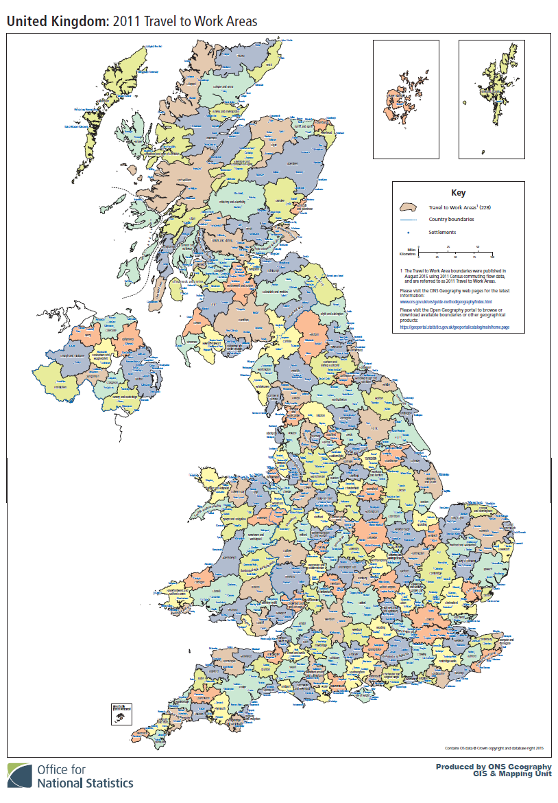 The 2011 TTWA map. More on the ONS website here.
There were 334 in 1981; 308 in 1991; 243 in 2001; and 228 in the latest data based on the 2011 Census. In other words, economically speaking, we’re losing cities at the rate of about 3 or 4 per year.
This is a reminder that neighbouring places are more inter-dependent, economically, than many political leaders would care to admit. Therefore, the map is particularly relevant to the ongoing devolution and decentralisation agenda.
Comparing the latest map with the previous map from 2001 shows several casualties, and emerging regional capitals, as the UK’s economic geography continues to shrink:
- Quite helpfully, Manchester has swallowed neighbouring Bolton, Rochdale and Oldham. Its commuter footprint now looks well-sized along the lines of the 10 local authorities that together form the Combined Authority. The one exception is Wigan, which forms a TTWA with Warrington following the M6 and West Coast Main Line.
- The data is telling the West Midlands that it’s less and less economically fragmented: Kiddeminster and Walsall have vanished, being absorbed into Worcester and Wolverhampton respectively. Rugby has been sucked into Coventry. This could help reinforce a sense of shared endeavour around getting devolved powers from central government.
- The travel-to-work patterns around Leeds, Sheffield, Nottingham, Leicester have been pretty stable between 2001 and 2011. Leeds and Sheffield are fragmented, while Leicester and Nottingham are single units. Matlock, in the Peaks, loses its own travel-to-work area, gobbled up by Derby and Chesterfield.
- Oxford’s footprint is edging outwards, taking in Dave’s village of Chipping Norton.
- Cambridge and Exeter are clearly booming: Exeter swallowed Tiverton and Okehampton, while the Cambridge commuter footprint now extends down to the M25, wiping out Harlow and Bishop’s Stortford. Economically, each is a regional capital taking in over 1000 square miles of rural areas into their orbit.
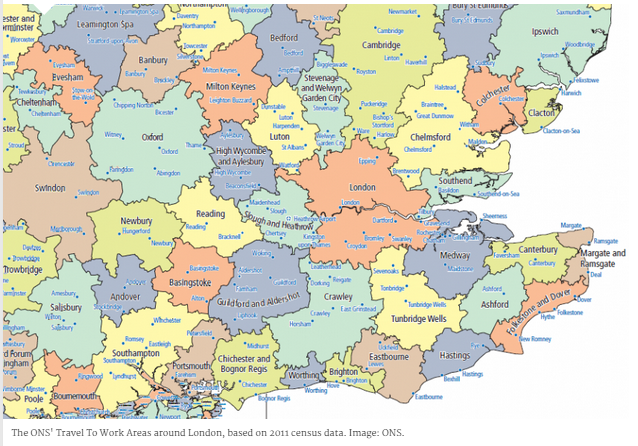
- Heathrow Airport has developed the gravitational pull of a city (and no wonder, over 70,000 people work there). The latest analysis gives it a new travel-to-work area which includes Maidenhead and Slough to the West, as well as Richmond and Uxbridge (where some notable Tory anti-Heathrow expansion MPs have made their political home).
- While London still draws a huge workforce from miles around, the airport has effectively shrunk London’s territorial dominance, economically speaking. First imagined in 1939, the aerotropolis of the future appears to have landed in the UK.
The case for working across council boundaries on skills provision, housing policy and economic development is starker than ever
So what does all this mean for those who work to have a positive impact on UK cities in the future?
The everyday routine of commuting shapes our identity and affinity with place. Having a common interest with our fellow citizens, even if that starts with sharing the experience of a journey to work, underpins the democratic mandate for new government structures like Combined Authorities. Newcastle and Gateshead may have a healthy rivalry, but analysis of travel to work shows they are economically inseparable. The case for working across council boundaries on skills provision, housing policy and economic development is starker than ever.
In part, the shape of the map also shows us some of the failures of policies of the past. When green belts were introduced, just one in seven households had access to a car: today it’s 80 per cent. By constraining housing growth immediately around Oxford and Cambridge, in particular, green belts explain the large travel-to-work areas for these cities, as thousands of commuters drive across each city’s green belt to get to work each day. This somewhat defeats the original rationale: green belts simply displace, rather than prevent sprawl.
Housing economics come in to play too: expensive cities tend to be job-rich and high-wage cities, attracting skilled workers and low-paid workers from less job-rich areas.
What would we expect to see in the 2021 map? If the US experience is a precedent, the next decade will see a boom in “super-commuting” over larger and larger distances. This doesn’t just refer to rich eccentrics and oil workers who “fly in fly out” between weeknights and weekends. Regular daily commuting between the four major conurbations of the Northern Powerhouse – Merseyside, Greater Manchester, South Yorkshire (Sheffield) and West Yorkshire (Leeds) – increased by over 20 per cent to over 100,000, between 2001 and 2011.
But super-commuting will become harder to measure because increasingly people work under flexible arrangements: working from home on certain days, or ‘in the field’ at client sites or branch offices of their business. While this might be good for the environment and reducing congestion, we underestimate the negative impact a longer commute will have on our well-being.
Similarly, our strong preference for private gardens doesn’t translate as much as we’d like to think to well-being benefits: we may get more use and social interaction from well-designed communal green space in dense urban developments.
By 2021, London will have speedier links to its east and west thanks to Crossrail; this may allow its commuting footprint to reconquer corners of Essex and Berkshire. On the other hand, it is Heathrow itself that will see the biggest improvement in connectivity – via Crossrail and other projects. We’ll have to wait and see if the concrete is being poured on the new third runway, and if the claimed growth in airport employment materialises.
But by then, we may be lobbying to use our Oyster Card on HS2 all the way up to Birmingham.
This article was originally published in CityMetric.
Join the discussion
Comments
Please login to post a comment or reply
Don't have an account? Click here to register.
An interesting analysis but what is happening in the North (and no, I don't mean Manchester or the North as defined from London bu Newcastle upon Tyne and its hinterland. Is there anyway I can enlarge the map to see?
Have a look here: https://geoportal.statistics.gov.uk/Docs/Maps/Travel_to_work_areas_(UK)_2011_map.pdf
80% of households may have access to a car across GB, but within cities the figure is much lower, down to 47% in London. Greenbelts stopped relentless low density sprawl in the UK in favour of rail-oriented commuter towns. That has had a hugely favourable impact on carbon emissions, as it turned out.
An interesting point, but I'd argue there's more at play, too...car ownership is very low in central London, but in outer London - where the Green Belt is - it's stubbornly high. Lots of people drive to rail stations in commuter towns on a weekday, and drive all over the place on a weekend.
Looking forward on Green Belt policy, recent work from RTPI made some interesting predictions: http://www.rtpi.org.uk/briefing-room/news-releases/2015/august/analysis-finds-building-in-the-green-belt-could-add-up-to-75m-extra-car-journeys-every-week/
All of this is marginal, in terms of carbon accounting, compared to the calculations involved in housing itself": embodied carbon and insulation efficiency among new/existing stock which exists at different (urban,suburban and rural) densities.
An interesting point, Edward. What the TTWAs can't accurately capture is the extent to which having London within easy reach provides some strength to local economic activity in Reading, Cambridge, Milton Keynes, Brighton etc.. While there clear commuting arteries along major road/rail corridors (M4/M3/A12 - see here http://www.huffingtonpost.co.uk/alasdair-rae/london-the-supernova-city_b_7654648.html), there are relatively weak data on economic linkages beyond commuting (one of the best attempts here: http://www.lboro.ac.uk/gawc/rb/rb224.html).
I agree with you on the insanity of housing (itself a princpal driver of inequality). I can also think of greater transport priorities than HS2 (the unrealised opportunity here being the ability to add housing along the WCML to NW of London).
However, I wouldn't call London's success baleful. London's growth has left many Londoners behind, but not sure who (or where) would be better off if we conspired to constrain the city in its 'business is booming' decades. Rather, we need to better accommodate that growth, and ensure the benefits flowing from it are better distributed among Londoners.
A thoughtful and thought-provoking piece. My one wished-for-more, was on the baleful influence of the metro-London success (so-called) story on the rest of the UK's cities. (So called as we are talking about a city with some of the most polarised and worsening extremes of unmerited inequalities among comparable cities, and with an ongoing housing crisis that defies rational analysis never mind policy-making). The London aspect is touched on at the end of the piece, but I fear that it has been, and going forward it will be, even more of an issue going forward. The H2S rail infrastructure project is not also likely IMO to turn out to be another one of the UK's costly heroic delusions - it amounts to a new super-commuter servicing channel for London. It will arguably be likely to further denude and debilitate the local economies of the those cities that will be further reduced to servicing metro London's wants and further aggrandisement. As for those cities left out of the HS2 orbit - well, as the academics would enjoin us... discuss!